We use lots of different tools around the web every single day, we thought our blog might be a good place to let others know what we find and how we use those tools (it also provides a good place for us to refer back to because we’re terribly forgetful when it comes to websites names!).
We were asked yesterday:
Is it possible to plot multiple points on a map, entering them one by one into Google Maps is just painful.
We can understand that, and went on a search for something to help our client, that’s when we found BatchGeo.
We particularly liked their quote:
We love maps, and we think they should be easy to make – that’s why we made BatchGeo. It’s the fastest way to create google maps from your data. It accepts addresses, intersections, cities, states, and postal codes. We do the hard work of figuring out where all your data lives in the real world.
BatchGeo allows you to copy and paste your data as a text file on their frontpage, make sure you’ve got a few headings in the text and before you know it you’ve plotted all your points with a simple cut and paste – it couldn’t be easier!
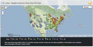
It’s not just about plotting the points either, it adds data to those points and can use different plot points for different ranges, here they’ve plotted US cities rain and snow days:
So if you need to plot your data in a different way, try BatchGeo.com


Leave a Reply